
For the best part of a decade now, Point Cloud Scanning has been touted as “the next big thing” in the architectural, engineering and construction industries. Being able to accurately map, measure and visualise complex 3D environments using Light Detection and Ranging technology (LIDAR) could potentially change the way we survey buildings and sites, rendering traditional methods obsolete. So after years of research and development, what are the advantages of point cloud scanning and what can we expect in the future?
What is Point Cloud Scanning?
First things first, a little overview of what point cloud scanning is might be helpful. Point clouds are the data collected by 3D laser scanning equipment. Applying the principles of LIDAR, the scanners feedback a single data point for wherever the light beams touch a surface. This will ultimately result in thousands or even millions of data points, which can then be processed using software to create a digital 3D model of your scan. The range and accuracy of this hardware is nothing to scoff at. The FARO FocusM 70, one of the most affordable laser scanners on the market at the moment, has a scan range of up to 70 metres, with an accuracy of +/- 3 mm.
What are the advantages?
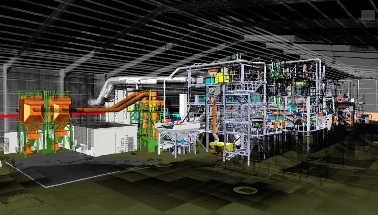
The advantages of this method are pretty clear. Let’s say you need to survey a busy plant room. A laser scan would allow you to pick up all of the existing pipe and ductwork within the building, which could then be processed digitally to produce a 3D BIM model in Revit. Scanning more complicated structures would require multiple scans, as the scanner’s beams cannot pass through walls, but ultimately this method would reduce the need for a labour-intensive and time-consuming survey on foot. Furthermore, the scan would provide greater coverage for poorly-lit, hard-to-reach areas that may prove difficult in a traditional survey. (Learn more about point cloud scanning benefits in our article: https://dats.co.uk/7-benefits-point-cloud-scanning/)
So point cloud scanning would minimise the time needed on site, but what happens when the data is taken back to the design office? Faro’s Senior Product Manager, Oliver Buerkler, believes in a holistic approach:
“We should not restrict ourselves to looking at laser scanning itself, but rather the complete workflow that the data enables. We are better placed to support clients with the full process in mind(1)”
According to Buerkler, the scan is only the beginning. The data variables allow for a greater amount of information, at a greater speed than traditional methods. The scan only need be captured once but the data can have a diverse range of uses, which can be adapted to meet your deliverables. The coverage and accuracy of point cloud data should provide a complete picture of your project, cutting out the need for return visits to site.
What software can it be used with?
Let’s get down to specifics. Point cloud scanning can be used in conjunction with a growing number of software packages, the most well-known being Autodesk ReCap. This software allows you to import your data for viewing and processing. From here you can transfer your information to other Autodesk products such as AutoCAD and Revit to create your output in both 2D and 3D formats. You can even import CAD geometry to your point cloud model to track progress throughout your project from the planning phase to construction. Furthermore, ReCap provides you with the tools to clean up your scans, removing noise and extraneous objects to help you produce a neat, professional-looking final product.
So has point cloud scanning arrived as the industry standard? With increased accessibility and ease of use, it certainly seems to be on its way. We’re excited to see where it goes next.
“If you think Point Cloud Scanning could be the perfect solution for your architectural, construction or engineering project, get in touch for an informal chat or to learn more.”

Coronavirus Update
Please be reassured that during this unsettling time, DATS is committed to continuing to partner with our clients, candidates and contractors as usual. Our business is open and we’re taking every precautionary measure to ensure the health and well being of our...

Benefits of Apprenticeships
Apprenticeships have long been prevalent in the engineering industry but have grown in popularity in all areas in recent years – maybe owing to the introduction of the Apprenticeship Levy in 2017. According to UCAS, there are now approximately 1500 different job role...

10 Predictions For Engineering Recruitment In 2020
The end of one decade marks a period of reflection, but it also provides a reason to look ahead. British engineering has undergone considerable change in the last 10 years. From the decline in oil and gas production to the arrival of BIM, CAD and 3D printing,...
Recruitment

Design
All